USGS
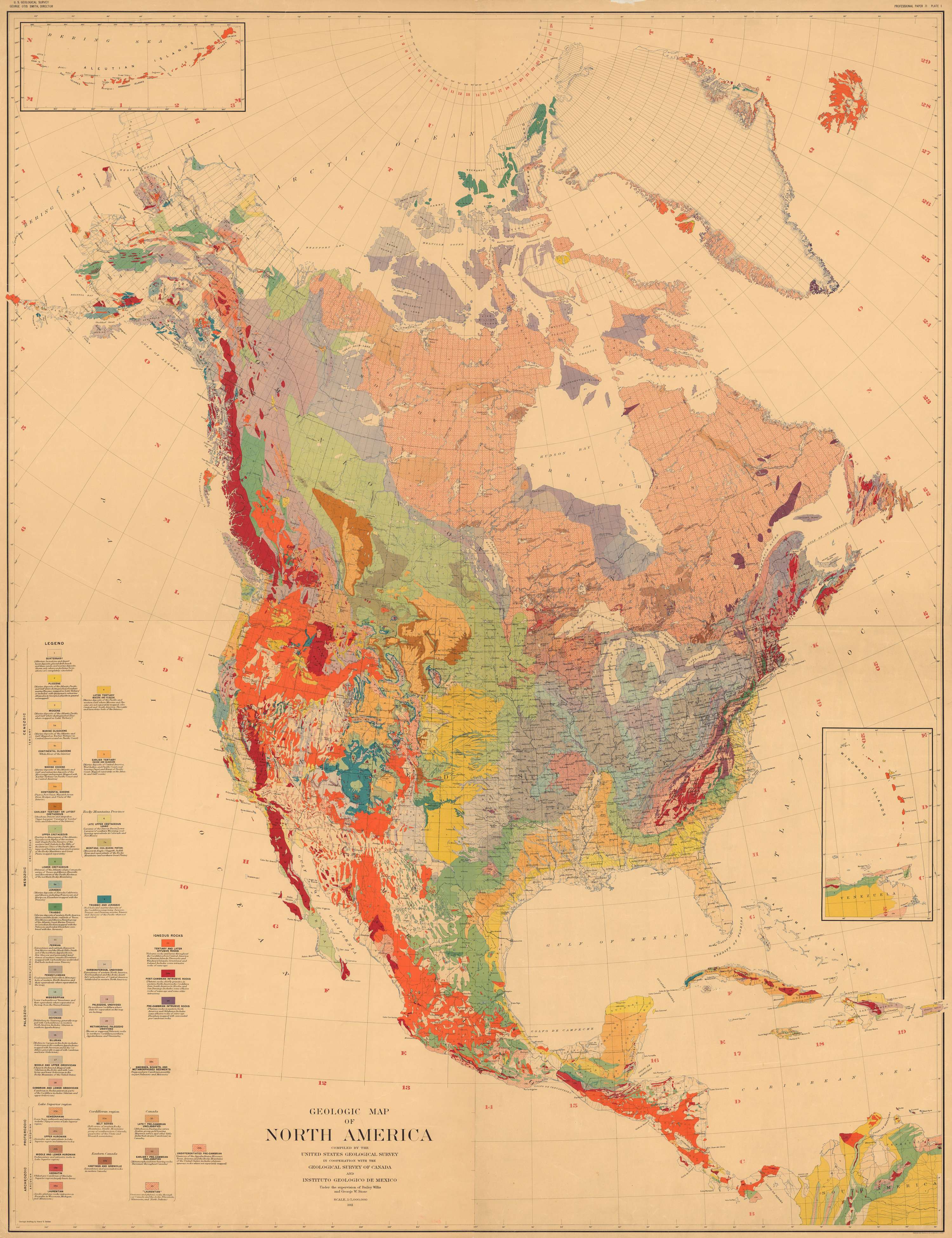
Geologic Map of North America
1911
An updated version of the 1906 map appeared five years later (Willis and Stose, 1911). The title block states that the map was “compiled by the U.S. Geological Survey in cooperation with the Geological Survey of Canada and Instituto Geologico de Mexico, under the supervision of Bailey Willis and George W. Stose.” The scale was also 1:5’000’000 and the base was essentially the same as the 1906 map, although meridians and parallels are shown at 1° intervals in land areas, the inset maps were rearranged, and many geographic names had been added. No faults or offshore data were shown. Blank areas in northwest Canada were filled; those in Alaska remained and some of them had been enlarged. Blanks in northern Canada remained. Geology along the southeast coast of Greenland was revised using new data.
Forty-two map units were distinguished and were identified by numbers on the map. Precambrian rocks were divided into Archean (5 units) and Algonkian (5 units) plus undivided Precambrian rocks and a unit of “gneisses, schists, and metamorphosed sediments (supposed pre-Cambrian; possibly in part Paleozoic and Mesozoic).” Paleozoic strata were divided into 8 map units, plus a unit of undivided Paleozoic sedimentary rocks and a unit of undivided Paleozoic metamorphic rocks. Other subdivisions included Mesozoic rocks (5 units), and Tertiary rocks (6 units). Igneous rocks comprised only 3 units: “pre-Cambrian intrusive rocks,” post-Cambrian intrusive rocks, and “Tertiary and later effusive rocks.”
The Canadian Shield was largely lumped as Laurentian, but “Late? pre-Cambrian” and “Earlier? pre-Cambrian” were broken out in a few places, and Precambrian granites were distinguished locally. More detailed subdivision of the Precambrian rocks in the Lake Superior region were shown in a separate column in the explanation. In the Cordillera, the map is much the same as in the 1906 version, but details were added, especially in central and western Alaska, although there was no hint of the Brooks Range. The Snake River Plain was well shown, and blanks in the Basin and Range province were filled.
In the southern Appalachians, the Blue Ridge was largely shown as Precambrian intrusive rocks, but some Paleozoic rocks were distinguished in the Grandfather Mountain window. The Piedmont was mapped as undivided Precambrian with extensive Paleozoic plutonic rocks and Precambrian intrusive rocks in eastern Virginia. Cambrian and Ordovician rocks in western Massachusetts pass northeast at a state line fault into metamorphosed Paleozoic rocks with widespread Paleozoic plutons in northeastern New England. Pennsylvanian sedimentary rocks were shown in the Boston Basin.

Lieu: USA
Scale: 1:5’000’000
Authors: George Willis Stose - Bailey Willis
Collection: David Rumsey Map Collection
Text: The Geological Society of America, Inc., Decade of North American Geology, 2005
Publié: Avril 2018
Catégorie: Cartographie