Leonz Held
Rhonegletscher
1874–1882
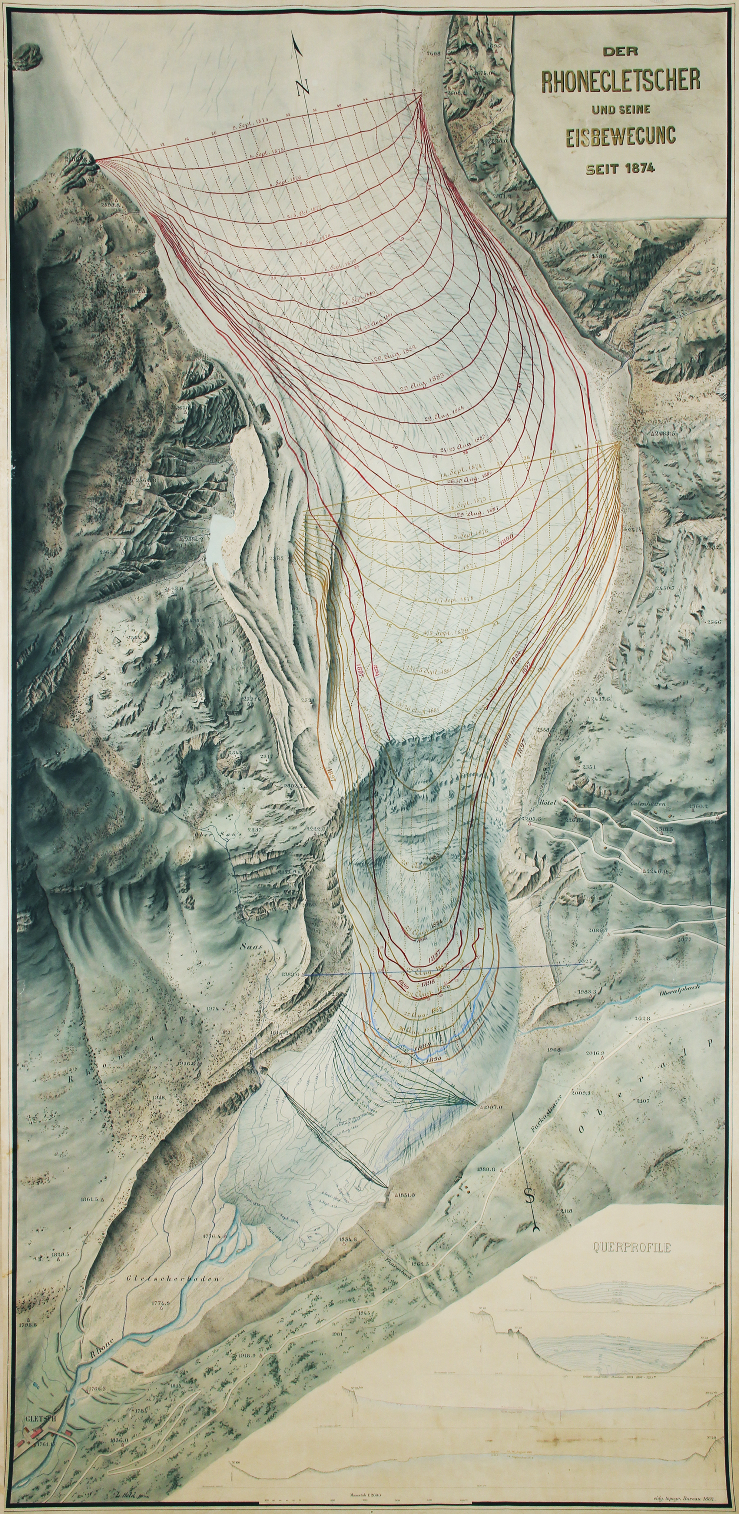
This map’s story begins in 1874, when the Swiss Alpine Club and the Swiss Association of the Natural Sciences founded the Glacier Commission to increase their involvement in this domain. The Rhône Glacier was chosen because of its easy accessibility and its structure, which is typical of an alpine glacier. Work started immediately with the technical support from the Federal Topographic Bureau, the organisation that later became the Federal Office of Topography. In 1881, topographer Leonz Held took charge of the technical side of the project and produced the map a year later. Drawn and painted entirely by hand, the map is a watercolour on a single sheet of paper in portrait format measuring 228 cm high and 115 cm wide. It was the only exemplar produced. The map shows the lower part of the glacier at a scale of 1:2’000 and has a slight north-north-east orientation. The assignment from the Glacier Commission originally specified a map at a scale of 1:5’000, but Leonz Held initially chose the scale of 1:2’000 to allow more space for illustrating the glacier’s movements.
The map not only depicts the topography of the terrain at a given point in time, but also shows the movements of the glacier between 1874 and 1899. To measure these, rows of coloured stone blocks were placed along straight lines perpendicular to the glacier. The progress made by each line of stones per year was then measured using fixed reference points marked on rocks bordering the glacier and is indicated on the map with successive coloured lines. This technique made it possible to record a flow rate of up to 210 m per year.
The sandur (zone between the glacier terminus and the Glacier du Rhône Hotel in Gletsch) already indicates a very clear retreat during this period. In the first edition of the Dufour Map of this region, published in 1854, the glacier still extends as far as Gletsch. The state of the glacier on the map from Held derives from the measurements of 1874 by Philipp Gosset, and the inconspicuous dates written in black and blue at its terminus indicate its retreat back to the blue line representing 1899, which is wider than the other lines. However, Leonz Held writes in a report by the Swiss Alpine Club from 1890 that the winters of 1887 to 1890 are isolated phases of glacier advance, attenuating the overall annual mass balance, which nonetheless remained negative. He even sounds optimistic when writing that a phase of more significant advance was “probable” in the near future. The historical record of the measurements of the Rhône Glacier indicates the next period of advance 22 years later in 1912, but the overall balance since the measurements began still shows an inexorable reduction in size.
Lieu: Rhône Glacier, Switzerland
Text: Federal Office of Topography (swisstopo)
Publié: Septembre 2019
Catégorie: Cartographie
Source